
Horse camping at Summit Lake Stock Corral, Lassen Volcanic National Park
Horse camping facts for Summit Lake Stock Corral in Lassen Volcanic National Park, from Recreation.gov, National Park Service: sites, rig length, trailer parking, horse trails nearby and the rules. Where an agency doesn't publish something, this page says so.
More horse camps, trailer parking, horse-legal trails and rules at Lassen Volcanic: Lassen Volcanic horseback riding.
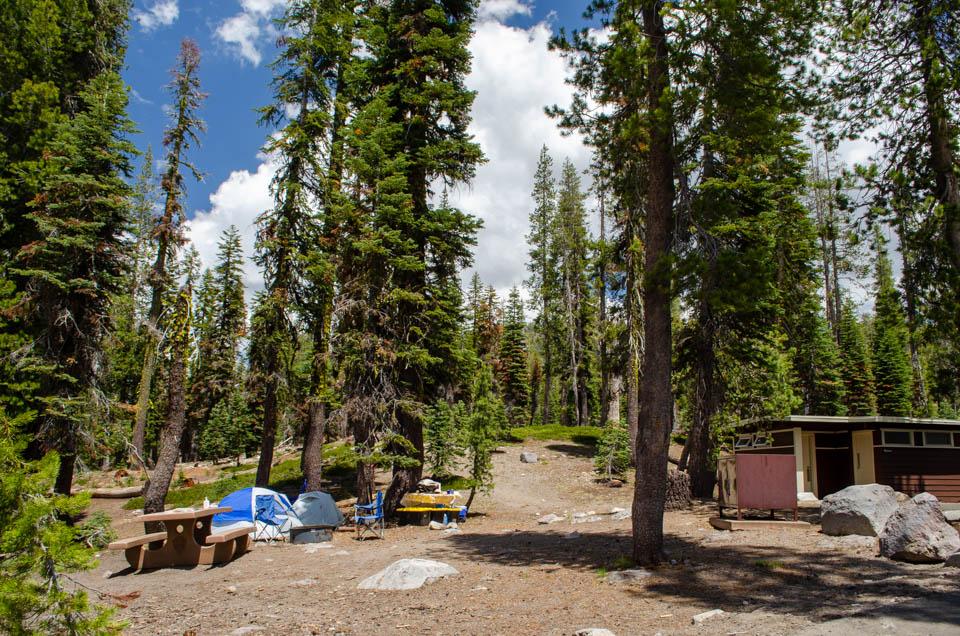
What are the horse camping facts at Summit Lake Stock Corral?
- Managed by
- National Park Service [1]
- Park or forest
- Lassen Volcanic National Park [1]
- Listed for horses as
- Equestrian campsites [2] (Recreation.gov)
- Horse sites
- 1 [2]
- Corrals
- Yes [2]
- Hitching posts
- Yes [2]
- Not published
- Not published by Recreation.gov or the National Park Service: max rig length, horses per site. Ridden here? Add it in Ride
- Reservations
- Reservations are required for all sites in the 2024 season. Reservations can be made up to 6 months in advance of arrival date up to the day of arrival. [1] Full text from National Park Service Book
- Coordinates
- 40.49444, -121.41750 [2] · Directions [2]
Where do I park a horse trailer at Summit Lake Stock Corral?
Max rig length at the camp: Not published by Recreation.gov or the National Park Service. Ridden here? Add it in Ride
No agency publishes horse-trailer parking for this camp. Ridden here? Add it in Ride
Nearest trailheads (trailer access unknown)
Summit Lake North Trailhead
Summit Lake South Trailhead
Cluster Lakes Trailhead
Nobles-Emigrant Trailhead
Hat Lake Trailhead
Kings Creek Falls Trailhead
Terrace Lake-Park Highway Trailhead
Drakesbad Trailhead
Which horse trails start near Summit Lake Stock Corral?
Pacific Crest Trail
Nobles Emigrant Trail
Pacific Crest Trail
Nobles Emigrant Trail
Butte Lake to Snag Lake Trail
Pacific Crest National Scenic
Butte Lake to Snag Lake Trail
Widow Lake to Snag Lake Trail
Widow Lake to Snag Lake Trail
Pacific Crest Trail
Mount Harkness Trail
Pacific Crest National Scenic Trail
Plus 96 more named horse-legal trails in the same data, not listed here.
Trails within about 9 miles where the managing agency (or OpenStreetMap) marks horses as allowed. Mileage is the mapped length of segments with that name, not a loop distance.
When is Summit Lake Stock Corral open?
- Season: June 25 – September 6 [23]
- Closed Winter to Late Spring / Early Summer: September 8, 2026 to June 26, 2027 [1]
As of October 25, 2026. Check with the agency before you haul: seasons move with snow and fire.
What are the horse rules at Summit Lake Stock Corral?
- More than 100 miles of trails are open to stock; stock are allowed on established/maintained trails except those listed as closed. [24]
- Trails closed to stock: Manzanita Lake, Lassen Peak, Cinder Cone, Reflection Lake, Bumpass Hell, and trails in the Devil's Kitchen and Sulphur Works hydrothermal areas and the Drakesbad closure. [24]
- "Group size is limited to 12 animals maximum." [24]
- "Camping with stock is not permitted in the backcountry." Overnight stays are allowed only in the park's stock corrals, and reservations are required (Recreation.gov). [25]
- "Certified weed-free feed must be provided by the camper." On trails, use processed grain or pellet feed with a nosebag; hay may be used in park stock corrals. [24]
- Free-trailing or loose-herding, and picketing and/or grazing of stock, are prohibited. [24]
- When leaving stock for short periods, tie them to a high line or hobble them near the trail, on a flat, sparsely vegetated site. [24]
- Stock must be kept at least 100 feet from lakes, proceed at a slow walk near people on foot, and stay off paved roads except to reach trails. [24]
- Each corral (Butte Lake, Juniper Lake, Summit Lake) is limited to 8 animals and 10 people; parking is limited to 6 licensed vehicles (Juniper Lake: 4). [25]
- "Hitch rails are not provided. Be prepared to use your trailer as a hitch rail." Portable corrals only inside designated corral enclosures. [25]
- Bag manure (bag no more than 1/4 full) and remove all feed from corrals before departure; clean sites of manure and uneaten food daily. [25]
- Temporary Dixie Fire closures to stock: PCT Corral Meadows north to Horseshoe Lake Trail junction; PCT south from Warner Valley Trailhead to Boiling Springs Lake; Warner Valley trails to Devil's Kitchen, Drake and Dream lakes; Drakesbad developed area. [25]
Is there water for horses at Summit Lake Stock Corral?
- Water for horses: Not published by Recreation.gov or the National Park Service. Ridden here? Add it in Ride
- Water hookup at the site: Not published by Recreation.gov or the National Park Service. Ridden here? Add it in Ride
- Drinking water (people): Yes - seasonal [1]
Ridden here?
Ride is a free iPhone app for logging rides, built for trail rides out of cell range: GPS keeps recording with no signal and the ride syncs later. If an agency hasn't published something on this page and you know it, add it in Ride.
 Free · iPhone · iOS 16.4+
What other horse campgrounds are near Summit Lake Stock Corral?
Packing for it: the horse camping checklist.
Sources
- National Park Service: https://www.nps.gov/lavo/planyourvisit/summit-lake-campground.htm, fetched October 16, 2026
- Recreation.gov: https://www.recreation.gov/camping/campgrounds/233358, fetched October 25, 2026
- OpenStreetMap contributors: https://www.openstreetmap.org/node/13121824647, fetched October 25, 2026
- OpenStreetMap contributors: https://www.openstreetmap.org/node/91312466, fetched October 25, 2026
- OpenStreetMap contributors: https://www.openstreetmap.org/node/91650118, fetched October 25, 2026
- OpenStreetMap contributors: https://www.openstreetmap.org/node/92545970, fetched October 25, 2026
- OpenStreetMap contributors: https://www.openstreetmap.org/node/9991663497, fetched October 25, 2026
- OpenStreetMap contributors: https://www.openstreetmap.org/node/5301614119, fetched October 25, 2026
- OpenStreetMap contributors: https://www.openstreetmap.org/node/92464583, fetched October 25, 2026
- OpenStreetMap contributors: https://www.openstreetmap.org/node/2925407419, fetched October 25, 2026
- OpenStreetMap contributors: https://www.openstreetmap.org/way/1336641677
- City of Redding: https://services2.arcgis.com/3cLBYFivUvlzVu0H/arcgis/rest/services/ShastaCountyTrailsStatus_Public/FeatureServer/0/query?where=OBJECTID%3D839&outFields=*&f=html
- City of Redding: https://services2.arcgis.com/3cLBYFivUvlzVu0H/arcgis/rest/services/ShastaCountyTrailsStatus_Public/FeatureServer/0/query?where=OBJECTID%3D838&outFields=*&f=html
- National Park Service: https://mapservices.nps.gov/arcgis/rest/services/NationalDatasets/NPS_Public_Trails/MapServer/0/query?where=OBJECTID%3D14983&outFields=*&f=html
- National Park Service: https://mapservices.nps.gov/arcgis/rest/services/NationalDatasets/NPS_Public_Trails/MapServer/0/query?where=OBJECTID%3D15071&outFields=*&f=html
- USDA Forest Service: https://apps.fs.usda.gov/arcx/rest/services/EDW/EDW_TrailNFSPublish_01/MapServer/0/query?where=objectid%3D10562124&outFields=*&f=html
- City of Redding: https://services2.arcgis.com/3cLBYFivUvlzVu0H/arcgis/rest/services/ShastaCountyTrailsStatus_Public/FeatureServer/0/query?where=OBJECTID%3D890&outFields=*&f=html
- National Park Service: https://mapservices.nps.gov/arcgis/rest/services/NationalDatasets/NPS_Public_Trails/MapServer/0/query?where=OBJECTID%3D16877&outFields=*&f=html
- City of Redding: https://services2.arcgis.com/3cLBYFivUvlzVu0H/arcgis/rest/services/ShastaCountyTrailsStatus_Public/FeatureServer/0/query?where=OBJECTID%3D943&outFields=*&f=html
- National Park Service: https://mapservices.nps.gov/arcgis/rest/services/NationalDatasets/NPS_Public_Trails/MapServer/0/query?where=OBJECTID%3D15281&outFields=*&f=html
- National Park Service: https://mapservices.nps.gov/arcgis/rest/services/NationalDatasets/NPS_Public_Trails/MapServer/0/query?where=OBJECTID%3D18705&outFields=*&f=html
- National Park Service: https://mapservices.nps.gov/arcgis/rest/services/NationalDatasets/NPS_Public_Trails/MapServer/0/query?where=OBJECTID%3D14896&outFields=*&f=html
- Recreation.gov: https://www.recreation.gov/camping/campgrounds/233358?tab=seasons, read and verified by hand October 16, 2026
- National Park Service: https://www.nps.gov/lavo/learn/management/stock_use_regulations.htm, read and verified by hand October 16, 2026
- National Park Service: https://www.nps.gov/lavo/planyourvisit/stock-use.htm, read and verified by hand October 16, 2026